
Pryor in Honduras in 2008
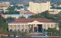
Presidential Palace of Honduras
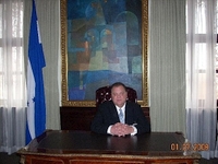
Jim Pryor at the Presidential Palace of Honduras.
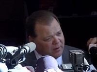
Press Conference at Presidential Palace
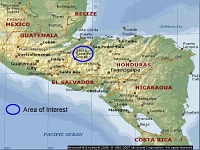
On December 5th 2007, Jim Pryor was asked by government officials to hold a news conference at the Presidential Palace to announce the first on-shore exploration for oil and gas in Honduras. The news conference was widely broadcast by news agencies. The efforts of Pryor and Witcher to determine and assemble the data to support oil/gas potential for Honduras was followed by their submission of documents and maps to secure an exploration license for a 741,000 acres tract in northern Honduras. Future wells drilled as a result of the work Pryor and Witcher performed over several years will represent the first exploration wells ever drilled on-shore in Honduras.
After the news conference, Pryor was quoted as saying, "This has been a huge project for us, as our resources are small compared to large companies. The difficulty we faced in the beginning was the lack of historical data. Honduras had never conducted relevant geological, geophysical, or basin studies. It is hard to enter a country that has never had wells drilled to provide information about the buried sedimentary column and try to unlock the secrets buried deep underground. Thankfully, a serious mapping project was carried out in the 1960s by a team of geologists led by R. A. Mills. Pryor and Witcher avoided several years of duplication of studies because of the immeasurable guidance and geological data provided by Mr. Mills, now retired. We, and the Nation of Honduras, owe Mr. Mills a huge debt of gratitude. We have named the region's major structural feature the "Mills Anticlinorium" in honor of Mr. Mills' work and talents dedicated to unravelling the mysteries of Honduras' geology.